Solar Thermal Drone Inspections in Central Illinois
Atlas Industrial Imaging provides thermal drone inspections for utility-scale solar farms, commercial solar arrays, and energy infrastructure across Central Illinois. Thermal imaging helps identify anomalies, underperforming areas, and maintenance priorities across large solar installations.
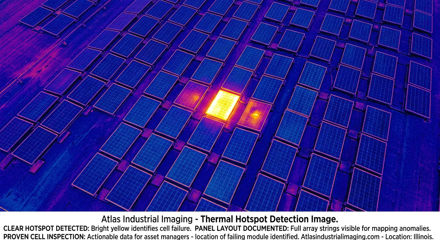
Thermal imaging — hot spot anomaly detection on commercial solar array
Thermal inspection for solar performance and maintenance workflows
Thermal drone imaging gives operators, owners, and maintenance teams a faster way to review large solar installations. Instead of checking arrays one small area at a time, aerial thermal inspection captures building-scale and field-scale patterns that help prioritize follow-up review and maintenance actions.
Large Array Coverage
Thermal drone surveys help document broad solar fields and large rooftop solar arrays efficiently.
Anomaly Detection Support
Thermal imagery can reveal irregular heat patterns that may indicate performance issues requiring further technical review.
Maintenance Planning
Visual and thermal documentation supports planning, prioritization, and repeatable inspection records over time.
Best-fit solar assets
Utility-Scale Solar Farms
Large rural solar sites where ground-only review is slow and incomplete.
Commercial Solar Arrays
Commercial and industrial properties with solar assets that require periodic performance review support.
Energy Infrastructure
Supporting energy sites where aerial thermal documentation helps create broader system context.
What this service can support
- Thermal review of solar panel fields
- Documentation of array layout and condition context
- Visual support for maintenance teams
- Repeatable thermal records over time
- Inspection support across large rural energy sites
- Commercial rooftop solar review support
- Utility-scale solar farm inspection workflows
- Energy infrastructure aerial documentation
- Broader site context for technical teams
- Central Illinois field-scale coverage
Related solar and infrastructure pages
Solar Farm Thermal Drone Inspections
Use-case page focused on utility-scale solar farm inspection workflows.
Central Illinois Solar Corridor
Energy infrastructure corridor page connecting the solar geography of the region.
Industrial Drone Inspections
Broader aerial inspection support for industrial and infrastructure environments.
Regional coverage for solar thermal work
Bloomington-Normal
Solar project access across McLean and surrounding counties.
Champaign-Urbana
Large rural land areas and expanding energy development.
Decatur
Industrial and energy infrastructure region with strong utility relevance.
Solar Farm Corridor
Regional energy corridor tying together utility-scale solar demand.
Need a thermal drone inspection for solar infrastructure?
Atlas Industrial Imaging provides thermal drone inspections for solar farms, commercial arrays, and energy infrastructure across Central Illinois.
Request Inspection